


sentier

trailer38
User

Length
4.3 km

Max alt
229 m

Uphill gradient
39 m
Km-Effort
4.8 km

Min alt
208 m

Downhill gradient
39 m
Boucle
Yes
Creation date :
2019-10-30 12:58:57.021
Updated on :
2019-10-30 14:44:40.088
1h44
Difficulty : Very easy

FREE GPS app for hiking
 SityTrail
IGN / Geographical institutes
SityTrail Plus
The world is yours!
About
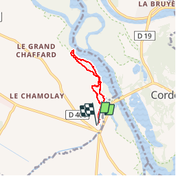
Trail Walking of 4.3 km to be discovered at Auvergne-Rhône-Alpes, Isère, Les Avenières Veyrins-Thuellin. This trail is proposed by trailer38.
Positioning
Country:
France
Region :
Auvergne-Rhône-Alpes
Department/Province :
Isère
Municipality :
Les Avenières Veyrins-Thuellin
Location:
Les Avenières
Start:(Dec)
Start:(UTM)
703497 ; 5055175 (31T) N.
Comments